Monitoring of a small forest catchment has been part of the measuring activities of the Košetice Observatory since the very beginning of the station. The monitored basin is located 1 km from the observatory, its area is 0,285 km2and the long-term average annual flow is 0,43 l.s-1, specific drain 1,49 l.s.-1.km-2. Approximately 90% of the watershed is forested, the rest is agricultural land. The forested part of the watershed is covered mainly by spruce monocultures, the predominant stands are around 90 years old with an admixture of pine, beech, larch and birch.
Forest stream is the only permanent tributary of the Anenská brook (Zelivka river basin). The watershed is operated as part of the international program of Integrated Monitoring ICP-IM (International Cooperative Program on Integrated Monitoring of Air Pollution Effects on Ecosystems), the aim of which is to know the substance balance and exchange of substances in small forested watersheds in the non-impact area.
The watershed is also part of the Czech monitoring system GEOMON, coordinated by the Czech Geological Survey . From a network of 14 small forest basins, they are collecting input data for the calculation of material flows of ecologically significant components using a uniform methodology, as a way of assessing the state and development of the natural environment. The means for such evaluation is the calculation of balances, i.e. inputs and outputs of components, in natural units of the biosphere represented by a small watershed. The entrance to the watershed is represented by deposition by undercrown precipitation (throughfall, THF) and precipitation on the free surface (BULK). Surface runoff is considered as the exit from the watershed.
On a 250 m long forest stream, there is a measuring device – a hydrological spillway, equipped with an ultrasonic probe with a registration unit for continuous measurement of water level, flow and air temperature. Flow values are regularly verified by manual measurement at the same time as water temperature measurement, which is not measured automatically. At regular monthly intervals, surface water samples are taken for chemical analysis at the hydrological overflow. Since 2008, the source of the forest stream has also been part of the underground water monitoring network of the CHMI.
Picture. 1 Surroundings of the Košetice Observatory
The soils in the area of the forest stream are developed on biotitic to two-mica paragules, the area is part of the oldest structural unit of the Czech Massif – Moldanubian. These are acidic brown forest soils of the distric cambisol type. Sampling and chemical analysis of soil samples took place in 1979, then in 1991, 1996, 2002, 2007 and 2015. The sampling site is two soil probes, in close proximity to which soil lysimeters were installed, to monitor the chemistry of soil water. Sampling takes place at two depth levels, 20 and 40 cm below the surface. Silicone-carbide suction cups are used for sampling, with which water is extracted under pressure from the unsaturated zone using a portable vacuum system. Samples are taken monthly.
Measurement of wet deposition (WET ONLY) is carried out on the Observatory property, currently it is a daily sampling by an Eigenbrodt automatic precipitation collector. Another type of precipitation sampling is wet deposition sampling with gravity deposition of larger particles – total deposition (BULK). This is the same sampling device as the THF located on the free surface of the observatory. Three sampling devices are used.
Atmospheric deposition represents the entry of substances from the atmosphere into other components of the natural environment. In addition to the monitoring of precipitation in the open area in the area of the Košetice Observatory, the deposition under the forest cover is measured. The monitoring of under-canopy deposition is situated at the eastern border of the forest catchment and has been carried out continuously since 1990. 20 sampling devices placed in stands on the diagonals of a 50 x 50 m square are used. This device consists of a liter PE bottle connected to a funnel with a catchment area of 113, 09 cm2. Sub-crown deductions are taken monthly. The monthly precipitation amount of THF and the chemical analysis of the precipitation water are determined.
Measurements outputs
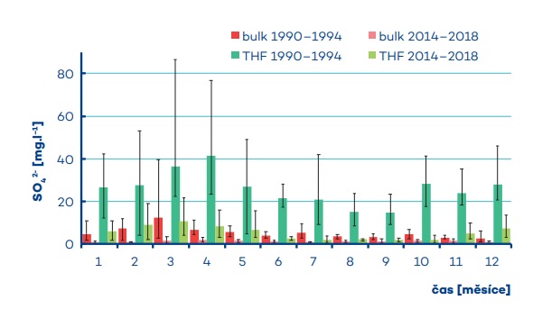
Průměrné koncentrace SO4 2- ve srážkách 1990–1994 a 2014–2018. Výška sloupců zobrazuje průměrné hodnoty. Horní/dolní konce chybových úseček označují maximální/ minimální hodnoty
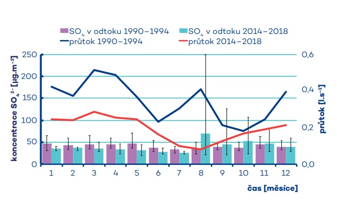
Průměrné koncentrace SO4 2-v odtoku v letech 1990–1994 a 2014–2018.
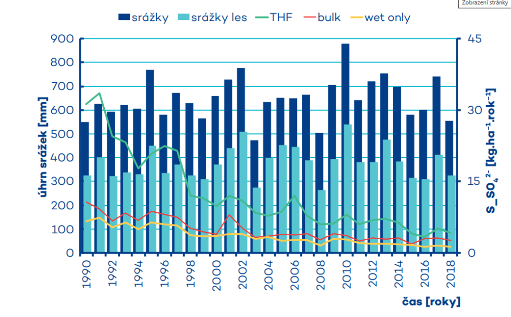
Srážkovo-odtoková bilance S_SO4 2- povodí.
Depozice S_SO4 2- ve vzorcích typu throughfall, bulk a wet only v lesním povodí.
Průměrné koncentrace SO4 2- v částicích v ovzduší 1990–1994 a 2014–2018. Výška sloupců zobrazuje průměrné hodnoty. Horní/dolní konce chybových úseček označují maximální/minimální hodnoty
Forest stream: Hydrological overflow with ultrasound probe